Regulator
Maritime NZ
Starlink’s land plans cover the sea to about 12 nautical miles from shore. Past that you need a maritime plan. In New Zealand that boundary happens to land on a line the regulator already uses: the 12 NM territorial sea, which is also the inshore fishing limit under Maritime Rules Part 20.
That coincidence makes the decision cleaner here than in most countries. If your operating limit is enclosed or inshore, an ordinary plan covers your whole working area. If it is coastal — a uniform 50 NM — you spend most of your range outside Starlink’s land coverage and need the maritime tier.
Every New Zealand commercial vessel carries an operating limit. Nobody publishes how it relates to Starlink’s coverage boundary, so here it is.
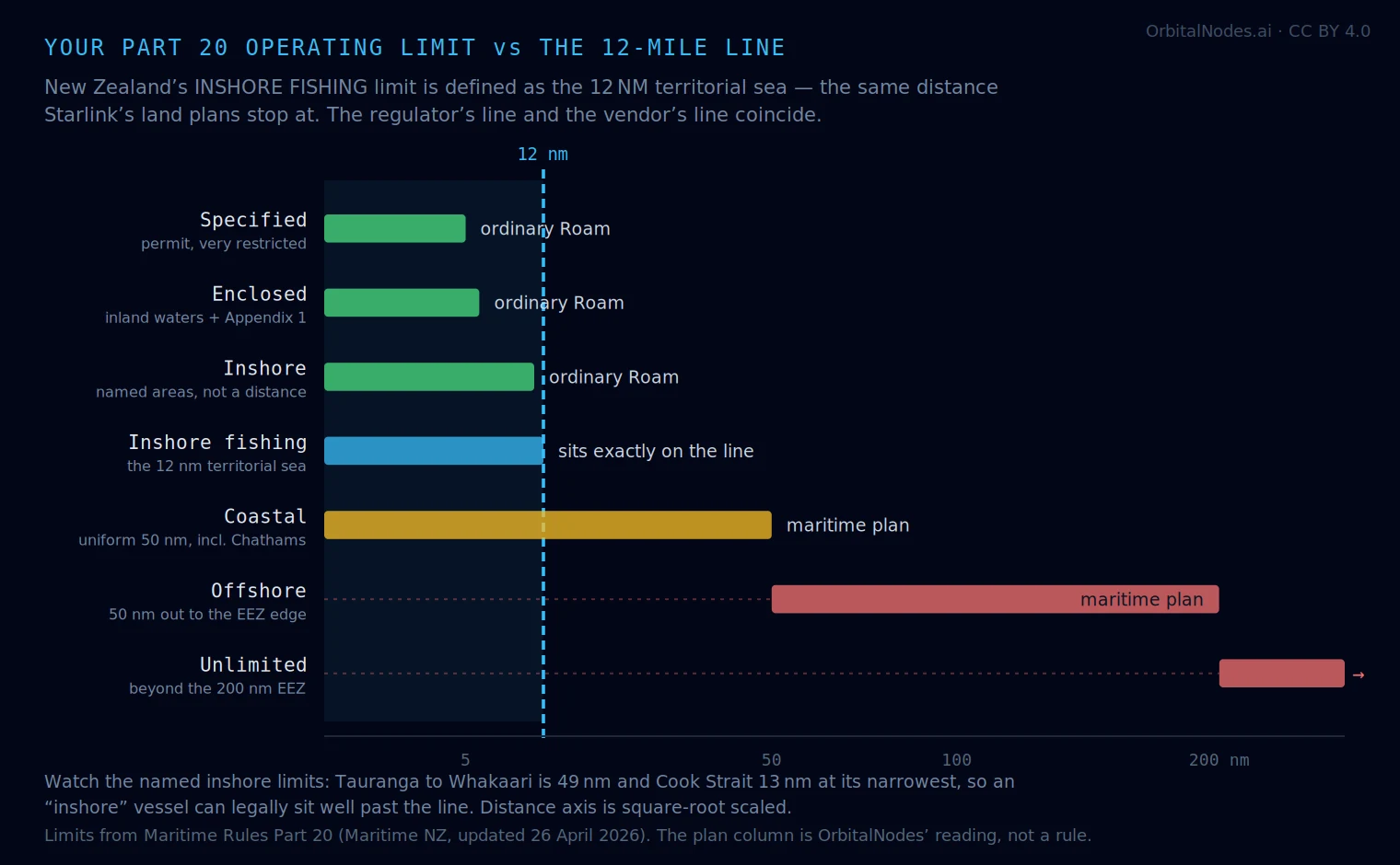
| Operating limit | Extent | Crosses 12 NM? | Plan you need |
|---|---|---|---|
| Specified | very restricted operations close to shore, by permit | No | ordinary Roam |
| Enclosed | Appendix 1 areas plus all NZ inland waters | No | ordinary Roam |
| Inshore | named areas “closely adjacent to sheltered waters” | Rarely | ordinary Roam |
| Inshore fishing | all waters within the 12 NM territorial sea | Sits on it | ordinary Roam, at the edge |
| Coastal | uniform 50 NM off North, South, Stewart and Chatham Islands | Yes, mostly outside | maritime plan |
| Offshore | coastal limit out to the edge of the EEZ | Yes | maritime plan |
| Unlimited | beyond the EEZ | Yes | maritime plan |
Operating limits from Maritime Rules Part 20 as explained by Maritime NZ, page last updated 26 April 2026. The 12 NM figure is Starlink’s published coastal coverage on land-based plans and is a global figure, not a New Zealand one. The plan column is ours — it is the mapping nobody else publishes, and it is a reading of two separate rule sets rather than anything either party states.
In Australia the equivalent boundary is a mess. AMSA’s Category C runs to 30 nautical miles, so a single certificate straddles the Starlink line — part of your legal range is covered and part is not, and the vessel has no way to tell you which. We mapped that separately.
New Zealand avoids it almost by accident. The inshore fishing limit is defined as the 12 NM territorial sea — the same distance Starlink stops at. So the regulator’s line and the vendor’s line are effectively the same line. Below it you are covered; above it you are into coastal limits and a different plan.
The other simplification: New Zealand’s coastal limit is a single uniform number, 50 NM, applied identically to the main islands and the Chathams. Australia’s categories run 30 NM and 200 NM with different rules attached. One number is easier to plan against than two.
This is the part worth knowing before you assume “inshore” means a fixed distance. New Zealand’s inshore limits are defined as named geographic areas, listed in the rule, and they were redrawn under the current Part 20. Three specific changes matter to anyone planning coverage:
Bay of Plenty was extended slightly to allow direct transits between Tauranga Harbour and Whakaari / White Island. That is a run of roughly 49 nautical miles — four times the 12 NM line, on a limit that sounds inshore. Whakaari sits about 28 NM off Whakatane, so the island itself is well outside Starlink’s land coverage.
Foveaux Strait was extended westwards to take in Codfish Island. And the inshore fishing limit carries an explicit boundary north of a line from 46°42′S 167°08′E to 46°42′S 167°18′E, giving direct access to Solander Island.
Cook Strait is the notable one. The old rule prohibited assigning an inshore limit to an individual vessel there; that prohibition has been removed, and a surveyor can now assign it to vessels of at least 12 m and under 500 GT. The strait is about 13 NM at its narrowest, between Cape Terawhiti and Perano Head, and considerably wider on the usual Wellington–Picton line — so an inshore-limited vessel can legally be at or past the edge of Starlink’s land coverage mid-passage.
All four changes are listed by Maritime NZ under “changes under the current Part 20”. The coverage implication is ours, not theirs — the rule is about crew competency, not connectivity, and nothing in it considers satellite coverage.
Trailer boats, harbour and estuary work, most charter: you are inside enclosed or inshore limits and inside 12 NM. An ordinary Roam plan covers your whole range. Do not pay for a maritime plan.
Inshore fishing: you are working right on the boundary, by definition — the limit and the coverage edge are the same line. Expect coverage across your permitted area and expect it to end exactly where your limit does.
Cook Strait crossings, Tauranga to Whakaari, outer Hauraki Gulf runs: check the actual distance offshore rather than trusting the word “inshore”. These are the passages where a limit that sounds coastal-hugging takes you past 12 NM.
Coastal, offshore or unlimited: a maritime plan, without much argument. Your legal range is 50 NM at minimum — four times Starlink’s land coverage — and out to the EEZ beyond that.
Chatham Islands: the 50 NM coastal limit applies there too, and the crossing from Wellington is roughly 415 NM. That is a maritime plan the whole way.
Two honest limits on this page. We have not tested Starlink at sea in New Zealand waters, and the 12 NM figure is Starlink’s own published coastal coverage rather than a measured boundary — real-world coverage varies with satellite geometry, and people report service both further out and patchier close in.
And your operating limit is a crew-competency and survey rule, not a coverage map. It tells you where you are permitted to go, which is what makes it a good proxy for what you need to plan for. It does not tell you where you will actually be on any given day.
If you are fitting out for genuine offshore work, the connectivity question is secondary to the safety one: a satellite plan is not a distress system. An EPIRB and a properly maintained VHF still do what no broadband dish does.
Operating limits, the Part 20 changes, the Bay of Plenty and Foveaux Strait extensions, the Cook Strait assignment rule and the Solander Island boundary coordinates are all from Maritime NZ, “Operating limits explained”, last updated 26 April 2026, which summarises Maritime Rules Part 20. Maritime NZ publishes operating-limit maps as PDFs for national certificates, fishing vessels, STCW vessels and domestic passenger vessels. The 12 NM coastal coverage figure is Starlink’s published global limit for land-based plans. The mapping between the two — the “plan you need” column and everything derived from it — is ours, and is a reading, not a rule. The full New Zealand coverage assessment is here.