Regulator
MCA
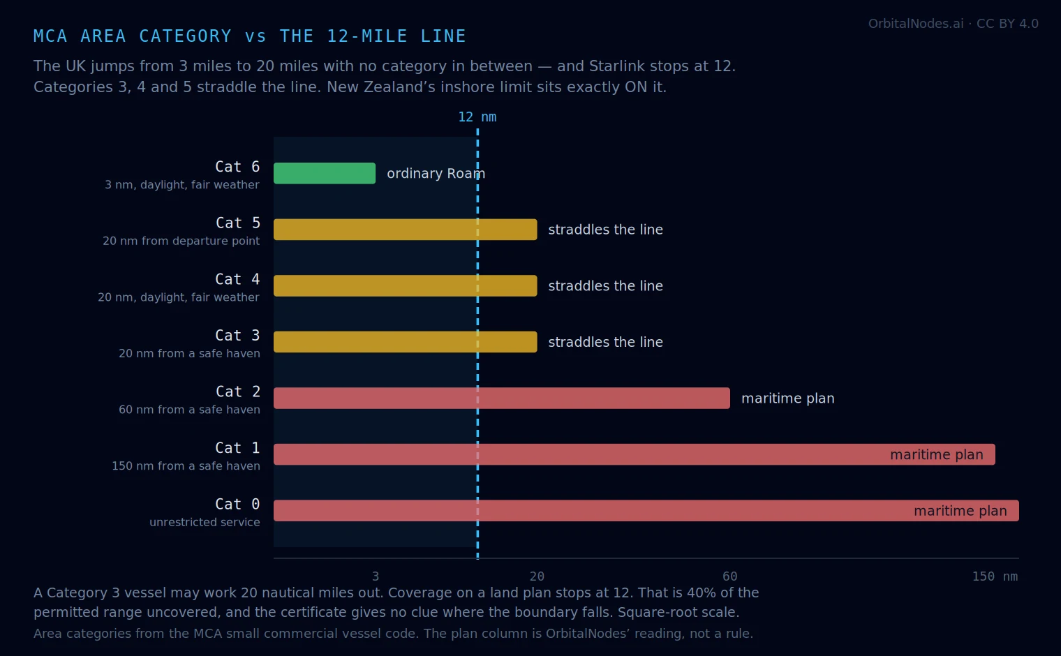
Starlink’s land plans cover the sea to about 12 nautical miles from shore. The UK’s area categories jump from 3 miles straight to 20, with nothing in between — so no MCA category lines up with where your coverage ends.
That leaves a specific trap. Categories 3, 4 and 5 all permit 20 nautical miles. A vessel coded to any of them can legally work 40% beyond where its land plan stops, and nothing on the certificate tells you where that boundary falls.
Nobody publishes how MCA coding relates to satellite coverage, so here it is.
| Category | Permitted range | Crosses 12 NM? | Plan you need |
|---|---|---|---|
| A–D (categorised waters) | sheltered inland waters, by wave height | No | ordinary Roam |
| Category 6 | 3 NM from a nominated departure point, daylight, fair weather | No | ordinary Roam |
| Category 5 | 20 NM from a nominated departure point, daylight, fair weather | Yes | maritime past 12 |
| Category 4 | 20 NM from a safe haven, daylight, fair weather | Yes | maritime past 12 |
| Category 3 | 20 NM from a safe haven | Yes | maritime past 12 |
| Category 2 | 60 NM from a safe haven | Yes, mostly outside | maritime plan |
| Category 1 | 150 NM from a safe haven | Yes | maritime plan |
| Category 0 | unrestricted service | Yes | maritime plan |
Area categories from the MCA small commercial vessel code, which applies to British-flagged vessels under 24 m carrying up to 12 passengers. The 12 NM figure is Starlink’s published coastal coverage on land plans and is a global figure, not a UK one. The plan column is ours — it is a reading of two unrelated rule sets, and neither party states it.
The UK splits its waters in a way neither Australia nor New Zealand does. Sheltered inland waters are classified A to D by SIGNIFICANT WAVE HEIGHT, not by distance — Category A is narrow rivers and canals generally under 1.5 m deep; B is wider water where waves stay under 0.6 m; C allows up to 1.2 m; D up to 2 m. The UK has over 4,000 miles of inland waterway on that system.
Everything beyond categorised waters is “at sea”, and there the numbered categories apply — counting down as you go further out, which catches people out. Category 6 is the most restricted; Category 0 is unrestricted.
For connectivity that split is useful: if you operate only in categorised waters you are inland by definition, and a land plan covers you completely. The question only arises once you are at sea.
New Zealand got lucky. Its inshore fishing limit is defined as the 12 NM territorial sea — the same distance Starlink stops at — so the regulator’s line and the vendor’s line coincide. We mapped that separately.
Australia is messy in the same way the UK is, but at a different distance: AMSA’s Category C runs to 30 nautical miles and straddles the boundary. That page is here.
The UK is the awkward one, for a different reason: the gap. There is no category at 5, 10 or 15 miles. You are either coded for 3 or coded for 20, and the 12-mile boundary sits in dead space between them. A Category 3 skipper has no regulatory landmark at all for where coverage ends.
Worth knowing if you are reading older guidance. On 12 December 2025 the MCA introduced a single unified code — The Safety of Small Vessels in Commercial Use for Sport or Pleasure — replacing the Blue, Yellow and Red Codes, MGN 280, and the Intended Pleasure Vessels Code. It is described as the most significant change in over twenty years, and sits under the Merchant Shipping (Vessels in Commercial Use for Sport or Pleasure) Regulations 2025.
The area categories themselves carry across, so the mapping above holds. But if you are checking requirements against a document that names MGN 280, you are reading a superseded code.
One more threshold worth knowing, and it is not about coverage: a vessel operating commercially more than 60 nautical miles from a UK safe haven, or outside UK waters, requires a Maritime Labour Convention inspection. That is Category 2 territory and beyond, and it is separate from the code itself.
Inland, estuary and harbour work: categorised waters A–D. Covered throughout on an ordinary plan.
Category 6 — day trips, RIBs, training within 3 miles: comfortably inside 12 NM. Do not pay for a maritime plan.
Categories 5, 4 and 3 — the 20-mile group: this is where to think. You lose coverage at 12 and your certificate says 20. If you routinely work the outer half of your permitted range, that is a maritime plan; if you rarely leave sight of land, it is not. The honest answer depends on what you actually do, not what you are coded for.
Categories 2, 1 and 0: a maritime plan, without much argument. Sixty miles is five times Starlink’s land coverage, and unrestricted is unrestricted.
And the standing caveat: a satellite plan is not a distress system. An EPIRB and a properly maintained VHF still do what no broadband dish does.
Area categories 0–6 and the categorised-waters classes A–D are from the MCA small commercial vessel code and the MCA’s published guidance on inland water categorisation; the water classes are defined in MSN 1837. The unified code taking effect 12 December 2025 and the regulations behind it are as announced by the MCA and reported by the RYA. The 60-mile Maritime Labour Convention threshold is from RYA guidance. The 12 NM coverage figure is Starlink’s published global limit for land plans. The mapping between the two — the “plan you need” column, the diagram and the 40% figure — is ours, and is a reading rather than a rule. The full UK coverage assessment is here.